|


 The Company has recently received an aerial magnetic survey completed by Terraquest Ltd. and a ground based Gravity Survey completed by Allan Spector & Associates. The recent work defines a wnw-trending gravity anomaly that parallels the regional gravity anomaly that demarks the major deformation/alteration zone hosting the Goldcorp Red Lake Mine and the Placer Dome Campbell Mine. This potential parallel deformation zone is crosscut by northeast trending faults as defined in the recent magnetic survey. The interpreted deformation zone consists of high-density mafic-intrusives, and mafic volcanics, bounded by granodiorites to the north, and granodiorites and mafic volcanics to the south. The Company has recently received an aerial magnetic survey completed by Terraquest Ltd. and a ground based Gravity Survey completed by Allan Spector & Associates. The recent work defines a wnw-trending gravity anomaly that parallels the regional gravity anomaly that demarks the major deformation/alteration zone hosting the Goldcorp Red Lake Mine and the Placer Dome Campbell Mine. This potential parallel deformation zone is crosscut by northeast trending faults as defined in the recent magnetic survey. The interpreted deformation zone consists of high-density mafic-intrusives, and mafic volcanics, bounded by granodiorites to the north, and granodiorites and mafic volcanics to the south.
|

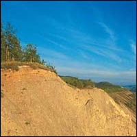
The newly acquired Bullion Hills project is located within the prolific Tintina Gold Belt of Alaska, which hosts a number of large lode gold deposits including NovaGold’s Donlin Creek property. The 470 hectare property is approximately 240 kilometres by road northeast of Fairbanks, Alaska, in the historic Circle Mining District. Bullion Hills also contains geological similarities to the recent lode gold discovery by Underworld Resources (UW: TSXV on their White Gold Project of May, 2009. |
|
|